The Big Aha!!!!
Mary is no longer available for RV traveling, but we remain good friends.
Sadly Mary is struggling with health issues. To see the latest about her situation, click here
To view past blogs, scroll to the bottom of this page and use the menu.
I’m currently in my 24th year of full-time RVing and my lifestyle is changing, For more info click here
The Big Aha!!!!…
Yesterday I drove the motorhome 56.9 miles from Palm Desert, California to my mysterious destination… an oasis in the desert, that I’ve hinted about in recent postings. For a short time longer, I’m going to remain unrevealing as to exactly where the motorhome is parked.
I’m doing so because I’ve had a lot of fun giving the mysterious location clues and I want to continue having more fun for a little while longer. Actually I have a couple of followers who are going slightly crazy themselves, being unable to identify the location from the provided clues. So more clues will follow until I either run out of clues or they figure out the location. 🙂
So far, the clues have revealed these facts about this mysterious destination…
- 1) It gets really hot here in the summertime.
- 2) It’s in California
- 3) It’s a place of beautiful sunrises and sunsets
- 4) It’s an oasis… an island in the desert…
- 5) It’s in Riverside County
- 6) the elevation is 722 feet according to Google earth
- 7) the population was 204 in 2010 according to Wikipedia
- 8) It’s 62.9 miles to the nearest Costco
And here’s another clue #9… It’s 52.3 miles to the nearest Walmart.
And here’s a bonus clue #10… Remember I’m an Ex-Engineer, which means read the clues carefully! 🙂
Now, all that remains to be disclosed is the mysterious destination location and the WHY I came here.
I’m wondering if any of you have figured out that the WHY, is a WOMAN!
So, that is the BIG AHA!
It’s truly hard even for me to believe, that for the first time in 36 years, I’m going to be living full-time with a WOMAN!
The other really big news is because I’m starting a new life with this woman, that after 3,713 postings in 3,686 days, this will be the LAST BLOG using the otrwjam wordpress address.
That means as of tomorrow morning if you desire to continue following our new life adventures, you will need to go to your URL address box after 7 AM (PDT) and enter the new blog site address of… or come back and click this link…
By going to that address, the first blog will explain all! I hope you will be joining us as she is a most unique gal and there will be LOTS of adventures and laughter!
In the meantime, here’s my usual parking location photos, which also provide clue #11… there is a lake here. The lake has also been visible in several of the photos shown so far.
As always you may left click upon an image to see an enlarged view…
Entering the oasis…

My parking spot through the front windshield…

the usual dinette window photo…

And a side shot from from the patio…

Also here’s a Google earth image showing my location. The motorhome location is shown as a yellow marker…

The first breakfast… all Keto… yummy…

The first supper… smothered pork chops…all Keto… yummy…

Here’s another big clue of what awaits you…
In the new blog site my new lady and I will use the pseudonyms of…
Brucie Bulldog and Rosie Eliza Looney! Let the fun begin!!!!
See you there or be square! 🙂
PS: don’t forget the new address you must enter in your URL address box after 7 AM is… or come back and click this link…
See you tomorrow on the new site! Oh what to heck… here’s another clue…
osclb are the initials of our new blog site…
Our Slightly Crazy Looney Bin!
PPS: For those who wish to continue following Mary, my former travel companion, you may do so by going to her personal blog site at… https://marysramblins.blogspot.com/
(You will note her last post is dated March 24, 2018. In my recent visit to her home she indicated to me that she hopes to resume publishing in the near future.)
I hope you enjoyed the photo.
Forecast for today is sunny and 84 degrees.
Enjoying nice weather is another joy in the life of a full-time RVer!
The red dot on the below map shows my approximate location in the State of California. You may double left-click the map to make it larger…

Enjoying 65-75 degree temperatures with low humidity most of the year is a primary joy in the RVing lifestyle!
“Life is like riding a bicycle. To keep your balance you must keep moving”…Albert Einstein

My current travel rig is a 2006 Fleetwood 26′ Class A Motorhome and a towed 1986 Ford Bronco II, Eddie Bauer Model. This photo was taken in the desert at Slab City near Niland, California…

On October 27, 2012, I created a two-minute video titled America The Beautiful. The music America The Beautiful is by Christopher W. French. The photos, which I randomly selected, are from the states of Arizona, California, Colorado, Florida, Georgia, Louisiana, Massachusetts, Mississippi, Montana, New Mexico, North Carolina, Oklahoma, Oregon, Pennsylvania, Texas, Tennessee, Washington and West Virginia (not shown in that order)…are mine. Yup, That’s me standing in front of the Post Office in Luckenbach, Texas…Y’all!
Click this link to start the video. Make sure you have your speakers turned on and go to full screen asap.
http://youtu.be/FfZUzEB4rM8
If you would like to see my YouTube videos, click this link… http://www.youtube.com/user/JimJ1579/videos
There are more than 700 photo albums in my Picasa Web Albums File. To gain access, you simply have to click this link… https://get.google.com/albumarchive/110455945462646142273?source=pwa
If you have not checked out my Ramblin Man’s Photos Blog, you can do so by clicking this link…http://ramblinmanphotos.wordpress.com/
For more information about my books, click this link:
http://www.lulu.com/spotlight/panamaorbust
All original works copyrighted – Jim Jaillet -2019
Acton To Palm Desert, California
Mary is no longer available for RV traveling, but we remain good friends.
Sadly Mary is struggling with health issues. To see the latest about her situation, click here
To view past blogs, scroll to the bottom of this page and use the menu.
I’m currently in my 24th year of full-time RVing and my lifestyle is changing, For more info click here
As always you may left click upon an image to see an enlarged view and then click once again to see an even larger view…
Crossing on the narrow roads across the high desert requires strong concentration…

After crossing Mountain Top Pass at 4,804 feet of elevation I began the steep decline into the Los Angeles Basin. Part of it is a steep decline on Interstate Highways 15/215/210/10…

I finally arrived at Thousand Trails Palm Springs RV Resort about 20 miles east of Palm Springs. Sunny and 94.2 degrees with only 2% humidity. A little to hot for my liking…

The usual dinette window view photo…

Here’s a Google Earth view of the 397 site park with my location marked by the X…

It has 805 tall date trees and is set on 25 acres. You can read about this place by clicking this link… http://www.thousandtrails.com/california/palm-springs-rv-resort/
I’ll depart here later this morning. Next stop is my mysterious destination location… an oasis in the desert, which is a mere 56.9 miles away!
Here’s another clue… It’s also 62.9 miles from the nearest Costco.
Be sure to see tomorrow’s blog entry. Lot’s of adventure and laughter ahead! 🙂
I hope you enjoyed the photos.
Forecast for today is sunny and 80 degrees.
Enjoying nice weather is another joy in the life of a full-time RVer!
The red dot on the below map shows my approximate location in the State of California. You may double left-click the map to make it larger…
Enjoying 65-75 degree temperatures with low humidity most of the year is a primary joy in the RVing lifestyle!
“Life is like riding a bicycle. To keep your balance you must keep moving”…Albert Einstein
My current travel rig is a 2006 Fleetwood 26′ Class A Motorhome and a towed 1986 Ford Bronco II, Eddie Bauer Model. This photo was taken in the desert at Slab City near Niland, California…
On October 27, 2012, I created a two-minute video titled America The Beautiful. The music America The Beautiful is by Christopher W. French. The photos, which I randomly selected, are from the states of Arizona, California, Colorado, Florida, Georgia, Louisiana, Massachusetts, Mississippi, Montana, New Mexico, North Carolina, Oklahoma, Oregon, Pennsylvania, Texas, Tennessee, Washington and West Virginia (not shown in that order)…are mine. Yup, That’s me standing in front of the Post Office in Luckenbach, Texas…Y’all!
Click this link to start the video. Make sure you have your speakers turned on and go to full screen asap.
http://youtu.be/FfZUzEB4rM8
If you would like to see my YouTube videos, click this link… http://www.youtube.com/user/JimJ1579/videos
There are more than 700 photo albums in my Picasa Web Albums File. To gain access, you simply have to click this link… https://get.google.com/albumarchive/110455945462646142273?source=pwa
If you have not checked out my Ramblin Man’s Photos Blog, you can do so by clicking this link…http://ramblinmanphotos.wordpress.com/
For more information about my books, click this link:
http://www.lulu.com/spotlight/panamaorbust
All original works copyrighted – Jim Jaillet -2019
One Day From Today…
Mary is no longer available for RV traveling, but we remain good friends.
Sadly Mary is struggling with health issues. To see the latest about her situation, click here
To view past blogs, scroll to the bottom of this page and use the menu.
I’m currently in my 24th year of full-time RVing and my lifestyle is changing, For more info click here
In the past few months I’ve indicated my 50+ year RVing life is changing. In my humble opinion, just like the world and the United States in general, not for the good.
5 days ago, I published my last blog posting on this topic. In case you missed it, here’s the link…
I’ve also indicated that on October 14th (tomorrow), I’m scheduled to arrive at a mystery location. A place my motorhome has never been to before. In addition, many other surprising changes await me there!
I’ve been having some fun offering clues about my mystery destination. My location here in Acton, California has me a mere 196 miles distant, waiting out hopefully lower temperatures. 🙂
So far the clues have revealed about this mysterious destination…
- It gets really hot there in the summertime.
- It’s in California
- It’s a place of beautiful sunrises
- It’s an oasis… an island in the desert…
- It’s in Riverside County
- The elevation is 722 feet according to Google earth
Here’s today’s really big clue… The population was 204 in the 2010 census per Wikipedia.
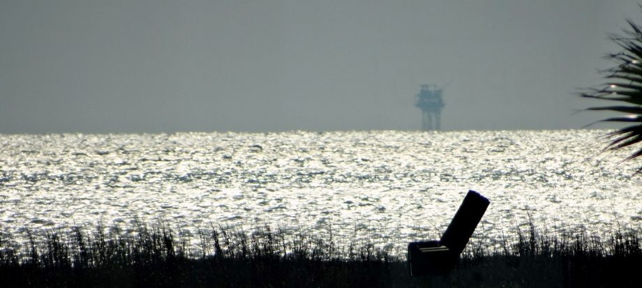
I’ve shown several beautiful sunrises as seen in photos provided by a friend. They also have some beautiful sunsets like the one seen in this photo provided by the same friend…

More clues and other changes coming soon! 🙂
I hope you enjoyed the photo.
Forecast for today is sunny and 88 degrees.
Enjoying nice weather is another joy in the life of a full-time RVer!
The red dot on the below map shows my approximate location in the State of California. You may double left-click the map to make it larger…

Enjoying 65-75 degree temperatures with low humidity most of the year is a primary joy in the RVing lifestyle!
“Life is like riding a bicycle. To keep your balance you must keep moving”…Albert Einstein
My current travel rig is a 2006 Fleetwood 26′ Class A Motorhome and a towed 1986 Ford Bronco II, Eddie Bauer Model. This photo was taken in the desert at Slab City near Niland, California…
On October 27, 2012, I created a two-minute video titled America The Beautiful. The music America The Beautiful is by Christopher W. French. The photos, which I randomly selected, are from the states of Arizona, California, Colorado, Florida, Georgia, Louisiana, Massachusetts, Mississippi, Montana, New Mexico, North Carolina, Oklahoma, Oregon, Pennsylvania, Texas, Tennessee, Washington and West Virginia (not shown in that order)…are mine. Yup, That’s me standing in front of the Post Office in Luckenbach, Texas…Y’all!
Click this link to start the video. Make sure you have your speakers turned on and go to full screen asap.
http://youtu.be/FfZUzEB4rM8
If you would like to see my YouTube videos, click this link… http://www.youtube.com/user/JimJ1579/videos
There are more than 700 photo albums in my Picasa Web Albums File. To gain access, you simply have to click this link… https://get.google.com/albumarchive/110455945462646142273?source=pwa
If you have not checked out my Ramblin Man’s Photos Blog, you can do so by clicking this link…http://ramblinmanphotos.wordpress.com/
For more information about my books, click this link:
http://www.lulu.com/spotlight/panamaorbust
All original works copyrighted – Jim Jaillet -2019
Central America Trip #93
Mary is no longer available for RV traveling, but we remain good friends.
Sadly Mary is struggling with health issues. To see the latest about her situation, click here
To view past blogs, scroll to the bottom of this page and use the menu.
I’m currently in my 24th year of full-time RVing and my lifestyle is changing, For more info click here
Today… A trip down memory lane!
2004 Central America trip…
This trip ended up being 343 days and 16,000+ miles through the back-country of Mexico, Belize, Guatemala, Honduras, El Salvador, Nicaragua, Costa Rica and Panama. 11 rigs started the trip, within a week we broke into three smaller groups for ease of traveling. Only myself and one other rig went the full, pre-planned route. All the others dropped out for various reasons. All returned safely to the United States. I’m planning to show these photos, more or less, 10 a day, whenever I’m not doing something else deserving a blog entry. FINALLY, it must be remembered these photos are prior to my switching to digital in 2006. The films were developed during our trip and the lack of quality control sometimes is plainly evident.
Today…Mexico (north-bound) 18…
The motorhome is in Oaxaca, awaiting a new engine. I had no idea that it would take two months. In the meantime we explore Oaxaca, one of the most beautiful cities in Mexico. In our two months there…we got to know it well…
Another day trip in the Bronco, this time to the village of San Bartolo Coyotepec which is known for its black pottery…the only place we saw black pottery on the entire trip. I bought a small drinking cup…
As always you may left click upon an image to see an enlarged view and then click once again to see an even larger view…

There are many roadside eating places…

Chicken is abundant in Mexico and Central America…

Another church…


Another day trip, this time to the village of Tlacochahuaya where there is a 16th Century church with beautiful Indian murals…

This church has not been refurbished and was most interesting to see after being in service for over 400 years…

Back in Oaxaca we got a close-up of the giant’s faces…

They dance non-stop for hours to very loud music…

Here’s my trip website link…http://www.lulu.com/spotlight/panamaorbust
I hope you enjoyed the photos.
Forecast for today is sunny and 71 degrees.
Enjoying nice weather is another joy in the life of a full-time RVer!
The red dot on the below map shows my approximate location in the State of California. You may double left-click the map to make it larger…
Enjoying 65-75 degree temperatures with low humidity most of the year is a primary joy in the RVing lifestyle!
“Life is like riding a bicycle. To keep your balance you must keep moving”…Albert Einstein
My current travel rig is a 2006 Fleetwood 26′ Class A Motorhome and a towed 1986 Ford Bronco II, Eddie Bauer Model. This photo was taken in the desert at Slab City near Niland, California…
On October 27, 2012, I created a two-minute video titled America The Beautiful. The music America The Beautiful is by Christopher W. French. The photos, which I randomly selected, are from the states of Arizona, California, Colorado, Florida, Georgia, Louisiana, Massachusetts, Mississippi, Montana, New Mexico, North Carolina, Oklahoma, Oregon, Pennsylvania, Texas, Tennessee, Washington and West Virginia (not shown in that order)…are mine. Yup, That’s me standing in front of the Post Office in Luckenbach, Texas…Y’all!
Click this link to start the video. Make sure you have your speakers turned on and go to full screen asap.
http://youtu.be/FfZUzEB4rM8
If you would like to see my YouTube videos, click this link… http://www.youtube.com/user/JimJ1579/videos
There are more than 700 photo albums in my Picasa Web Albums File. To gain access, you simply have to click this link… https://get.google.com/albumarchive/110455945462646142273?source=pwa
If you have not checked out my Ramblin Man’s Photos Blog, you can do so by clicking this link…http://ramblinmanphotos.wordpress.com/
For more information about my books, click this link:
http://www.lulu.com/spotlight/panamaorbust
All original works copyrighted – Jim Jaillet -2019
Central America Trip #92
Mary is no longer available for RV traveling, but we remain good friends.
Sadly Mary is struggling with health issues. To see the latest about her situation, click here
To view past blogs, scroll to the bottom of this page and use the menu.
I’m currently in my 24th year of full-time RVing and my lifestyle is changing, For more info click here
Today… A trip down memory lane!
2004 Central America trip…
This trip ended up being 343 days and 16,000+ miles through the back-country of Mexico, Belize, Guatemala, Honduras, El Salvador, Nicaragua, Costa Rica and Panama. 11 rigs started the trip, within a week we broke into three smaller groups for ease of traveling. Only myself and one other rig went the full, pre-planned route. All the others dropped out for various reasons. All returned safely to the United States. I’m planning to show these photos, more or less, 10 a day, whenever I’m not doing something else deserving a blog entry. FINALLY, it must be remembered these photos are prior to my switching to digital in 2006. The films were developed during our trip and the lack of quality control sometimes is plainly evident.
Today…Mexico (north-bound) 17…
The motorhome is in Oaxaca, awaiting a new engine. I had no idea that it would take two months. In the meantime we explore Oaxaca, one of the most beautiful cities in Mexico. In our two months there…we got to know it well…
Another day trip in the Bronco, this time to the village of Cullapan de Guerrero where there is a vast, unfinished 16th Century convent. Work ceased in 1580 because of a land dispute. This place is huge, beautiful and was interesting to wander through and photograph. On that day a number of 15 year-old girls were celebrating their birthday. In Mexico, a girl’s 15th birthday is the second most important day in her life, second only to her wedding day…
As always you may left click upon an image to see an enlarged view and then click once again to see an even larger view…


Here’s my trip website link…http://www.lulu.com/spotlight/panamaorbust
I hope you enjoyed the photos.
Forecast for today is sunny and 68 degrees.
Enjoying nice weather is another joy in the life of a full-time RVer!
The red dot on the below map shows my approximate location in the State of California. You may double left-click the map to make it larger…
Enjoying 65-75 degree temperatures with low humidity most of the year is a primary joy in the RVing lifestyle!
“Life is like riding a bicycle. To keep your balance you must keep moving”…Albert Einstein
My current travel rig is a 2006 Fleetwood 26′ Class A Motorhome and a towed 1986 Ford Bronco II, Eddie Bauer Model. This photo was taken in the desert at Slab City near Niland, California…
On October 27, 2012, I created a two-minute video titled America The Beautiful. The music America The Beautiful is by Christopher W. French. The photos, which I randomly selected, are from the states of Arizona, California, Colorado, Florida, Georgia, Louisiana, Massachusetts, Mississippi, Montana, New Mexico, North Carolina, Oklahoma, Oregon, Pennsylvania, Texas, Tennessee, Washington and West Virginia (not shown in that order)…are mine. Yup, That’s me standing in front of the Post Office in Luckenbach, Texas…Y’all!
Click this link to start the video. Make sure you have your speakers turned on and go to full screen asap.
http://youtu.be/FfZUzEB4rM8
If you would like to see my YouTube videos, click this link… http://www.youtube.com/user/JimJ1579/videos
There are more than 700 photo albums in my Picasa Web Albums File. To gain access, you simply have to click this link… https://get.google.com/albumarchive/110455945462646142273?source=pwa
If you have not checked out my Ramblin Man’s Photos Blog, you can do so by clicking this link…http://ramblinmanphotos.wordpress.com/
For more information about my books, click this link:
http://www.lulu.com/spotlight/panamaorbust
All original works copyrighted – Jim Jaillet -2019
